With the integration of AI and satellite imagery, most navigation apps these days can monitor and report traffic status, calculate bus fares, create custom routes, and more. In this article, we bring you some of the best Google Maps alternatives for GPS navigation. Let’s begin.
1. Waze – Best Crowdsourced Navigation App
Calling Waze a unique user experience is much more accurate. This Android app sports a refreshing new interface that gives you a break from the monotony of Google Maps. You can also interact with other Wazers on your route, customize the icons for your vehicle, and even play your favorite song, right from the Waze app. With music integration, you can add your favorite music streaming app to the Waze map screen. Going around with Waze is also fun with all the animated location icons that pop up on the map screen. Waze will analyze and factor in any recent incident or disruption reports made along that route to give you the best route possible. However, Waze has no offline maps. It’s also lacking in features like terrain and a satellite view. While it has a better database for accident reports, pothole alerts, etc., this crowdsourced information can be inaccurate at times. Also, you cannot move your starting point to a location that’s more than 3000 miles away from your current location. Tip: You can also check out our comparison of Google Maps vs. Waze to make a better decision.
Platform Available: Web, Android, and iOS Price: Free
Get Waze for Android
Better accident and speed camera warnings Better recommendations for local services Music integration Easy-to-use user interface
No offline mode is available Can drain the device battery faster Restrictions on moving starting point away from current location
2. Citymapper – Best App for Journey Planning
Since its inception, Citymapper has been making use of real-time data to plan your route using the best transport services, including major public transit networks, available. You can also check for nearby scheduled buses, trains, bike rentals, cab pickup locations, etc., and get an inclusive ETA, right from the menu options. Unlike Google Maps, which gives you a brief look at your journey, Citymapper offers step-by-step route instructions on how you can go from point A to point B. It mentions minute details like whether your route is step-free or not, or which section your train is running. You can also check the total fare and even your total steps for the journey. One of the main drawbacks of using Citymapper is that it is still not as widely available as Google Maps. That means you can’t use their services if you travel to places currently unavailable on Citymapper. While most Citpmapper features are free, they offer a Club subscription for access to certain additional features and to remove ads from the app.
Platform Available: Web, Android, and iOS Price: Free; Club Subscription: $3.50/month onwards
Get Citymapper for Android
Includes real-time public transportation information Displays total route fare with rental fare The app also offers a step counter
The free version has ads Lacks coverage in certain areas
3. Sygic – Best Offline Navigation App
The ultimate app for offline navigation, Sygic lets you store area-wise maps. Depending on the area size, these maps are surprisingly compact in size and can be stored even on phones with limited capacity. It calculates the route using traffic data provided by TomTom and ensures you’re on the fastest route while being mindful of speed traps. In the free version, Sygic offers basic features like offline maps, route calculation, and offline search. You also get the option of managing your EV services by using the EV mode feature. Here, you can enter your vehicle’s details and it will lead you to designated EV routes where you can find EV charging stations like on Google Maps and more. However, major features are not available in the free version. Premium+ subscribers have access to features like Heads-up Display and Dynamic Lane, which can display your navigation information directly onto your vehicle’s windshield and help you effortlessly switch between lanes, all the while ensuring you stay within speed limits.
Platform Available: Android and iOS Price: Free; Subscription: 7 days free trial then $19.99/year
Get Sygic for Android
Better offline map options Dashcam and Heads-up modes in the paid version EV mode in the free version
The free version has limited features The interface isn’t user friendly
4. MAPS.ME – Best Feature-Packed Alternative to Google Maps
Add your favorite places, choose your starting point, and make plans to where ever you want, all from the home page of the MAPS.ME app. You can even download offline maps. So, once you have entered your route details, you can decide if you want to take the bus, car, bike, or cab. If the distance is short, you can also look at walking directions. You can either download area-specific maps or just the map for your current trip. If you go for trip-specific maps, the file might be bigger in size due to information like nearby facilities, eateries, etc., being included in the map data. Offline maps work better than Google Maps to determine your current location even without an active GPS connection. You can also turn on power saving mode, change the overall app appearance and color, and add a perspective view to the app. However, the MAPS.ME 3D location tracking services can cause a lag in loading the map, especially if the starting point of the journey is not your current location.
Platform Available: Android and iOS Price: Free
Get MAPS.ME for Android
Detailed offline maps Offline maps work better than they do on Google Maps Multiple transport modes for offline maps
3D location services can lag Moving starting point can disrupt the services
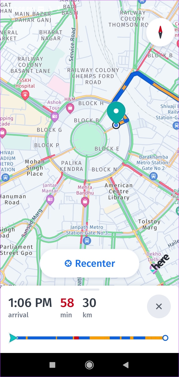
5. HERE WeGo – Best Alternative to Google Maps
The HERE WeGo app might take people some time to get used to due to the extensive options available. We get vehicle support options, with the ability to select between diesel, gasoline, and electric. You can also turn on the rest areas option to check if there are any rest areas available nearby. All these metrics are visible at the start of the journey. Also being used by big car companies, the HERE WeGo app comes with excellent features like offline maps, weather widgets, and a vast database of different points of interest. Now, with the tap of a button, you can easily see if there are restaurants, eateries, rest areas, etc. available on your route, especially when driving on a highway. While the HERE WeGo app is free to use, we found its 3D map feature lacking. Additionally, the app takes a while to select and suggest routes. To align this, you can customize your route profile by selecting between the fastest route and the shortest route. You can also choose routes that you are comfortable with, like avoiding highways, tunnels, ferries, etc. Tip: You can also want to check this comparison between Google Maps vs. HERE WeGo for more detailed information.
Platform Available: Web, Android, and iOS Price: Free
Get HERE WeGo for Android
Offline map options Gives detailed turn-by-turn navigation Optimize results based on vehicle fuel type Gives speed limit alerts
Route suggestions can be better App controls can be confusing
6. OsmAnd – Best App for Mapping Multiple Locations
Record, modify, reuse, and share your travel route with your friends using the OsmAnd GPS app. You can easily record your trip route, add new route information to older routes, and even edit this route information. You can also go through the Tracks option to find previous trip recordings. You can download up to 7 free maps for offline use. However, this also means that you can only download up to 7 free updates for these offline maps per month. While planning your trip, you also have the option of adding flags and video or voice notes along the way for a better understanding of the route and increased distance visibility. While the OsmAnd app is free to use, it has a subscription service as well that will give you access to additional features like cloud storage, Android Auto support, hourly map updates, etc. However, to access these features, you will need to subscribe and install the OsmAnd+ app separately.
Platform Available: Android and iOS Price: Free; One-Time Subscription: $24.99
Get OsmAnd for Android
Offline map and trip recording features Option to add flags along the trip route Supports Audio/video notes
Lacks Android Auto support in the free version The user interface can be confusing
Best Way to Get Around
With the constant innovation in technology, apps are always introducing new features to one-up each other. So, we hope that this article helped find some new and innovative alternatives for Google Maps. If you have any other app that you would like to recommend, let us know in the comments! The above article may contain affiliate links which help support Guiding Tech. However, it does not affect our editorial integrity. The content remains unbiased and authentic.